![]()
![]()
![]() SAR
Technology -
Aviation SAR Service
SAR
Technology -
Aviation SAR Service
- Managing the Air-Search Mission -
'Incident Commander Pro'
provides professional tools to plan,
deploy and manage the Air-Search Mission.
 |
|
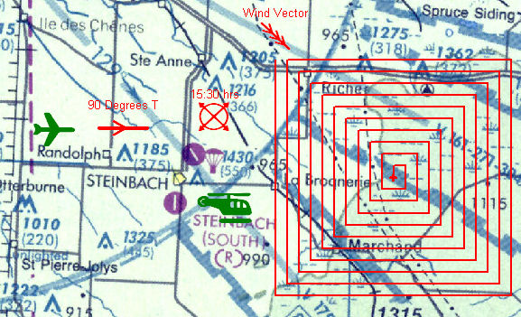
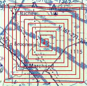
Aircraft Crash Distance Radius |
A powerful set of
integrated Data, Assignments, Communications and GIS-based Mapping tools provide
a comprehensive management system to assist with planning and conducting the
air-search mission.
 |
|
|
![]() Mission Briefings
Mission Briefings
An integrated Mission Status
Display, Flight Assignments, Mission Briefings, Resource
Status, Communications Log and Personnel Check-In forms
provide full operational briefings on the status of the active mission.
|
|
![]() Operational Status
Operational Status
![]() 'Incident Commander Pro's powerful
Real-Time Tracking includes the ability track both aircraft and ground
units on the GIS Map and Google Earth.
'Incident Commander Pro's powerful
Real-Time Tracking includes the ability track both aircraft and ground
units on the GIS Map and Google Earth.
![]() The
GIS Live Update feature automatically refreshes and re-plots the aircrafts' latest recorded positions
on the status map as this information is reported.
The
GIS Live Update feature automatically refreshes and re-plots the aircrafts' latest recorded positions
on the status map as this information is reported.
The Communication Log and Mission Status Display provide
real-time updates of the current communication and operational status of the
mission.
 |
|
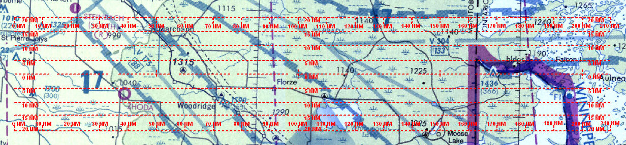
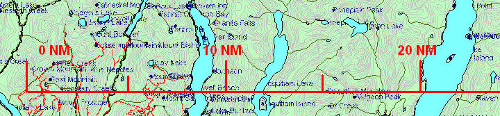
Aeronautical Scalebar |
 |
|
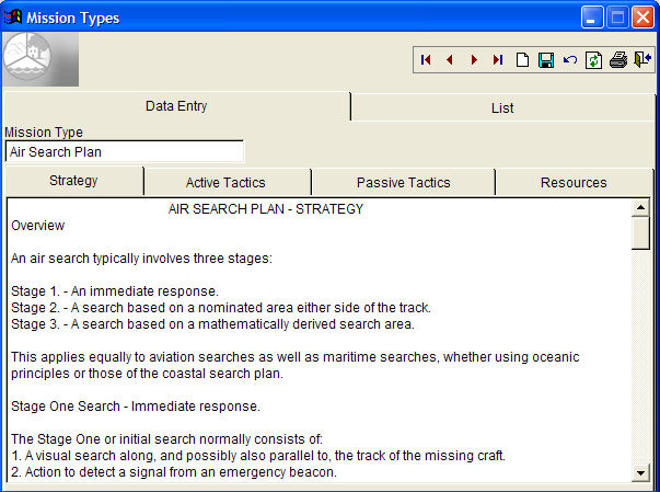
Example Air -Search Mission Type |
![]() Mission Planning
Mission Planning
Air-Search Patterns,
Air-Search Mission Type, ![]() Flight Search Speed/Altitude tables and
Flight Search Speed/Altitude tables and ![]() Aeronautical Mapping Symbols all provide the ability to customize the pre-plan and mission response in both training and operational missions.
Aeronautical Mapping Symbols all provide the ability to customize the pre-plan and mission response in both training and operational missions.
 Flight Routes drawn on the GIS map can be exported for loading into GPS units.
GPS flight tracks can be downloaded and plotted on the GIS map display.
![]() Combined
with it's comprehensive Incident Command structure, powerful reporting functions and
integrated aircraft tracking capabilities, 'Incident Commander Pro' is
a powerful tool for monitoring and supporting the air-search mission.
Combined
with it's comprehensive Incident Command structure, powerful reporting functions and
integrated aircraft tracking capabilities, 'Incident Commander Pro' is
a powerful tool for monitoring and supporting the air-search mission.
![]() Probability
of Detection Calculator - for aircraft/target type, terrain and flight track spacing.
Probability
of Detection Calculator - for aircraft/target type, terrain and flight track spacing.
 |
|
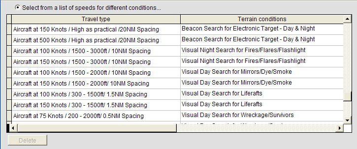
Travel Speed & Track Spacing for Air-Search Targets |
For more information please contact:
![]() SAR
Technology Inc.
SAR
Technology Inc.
 Phone:
(604) 921-2488
Phone:
(604) 921-2488  Fax (604) 921-2484
Email: ![]() sartechnology@telus.net
sartechnology@telus.net
![]() martincolwell Linked
in
martincolwell Linked
in
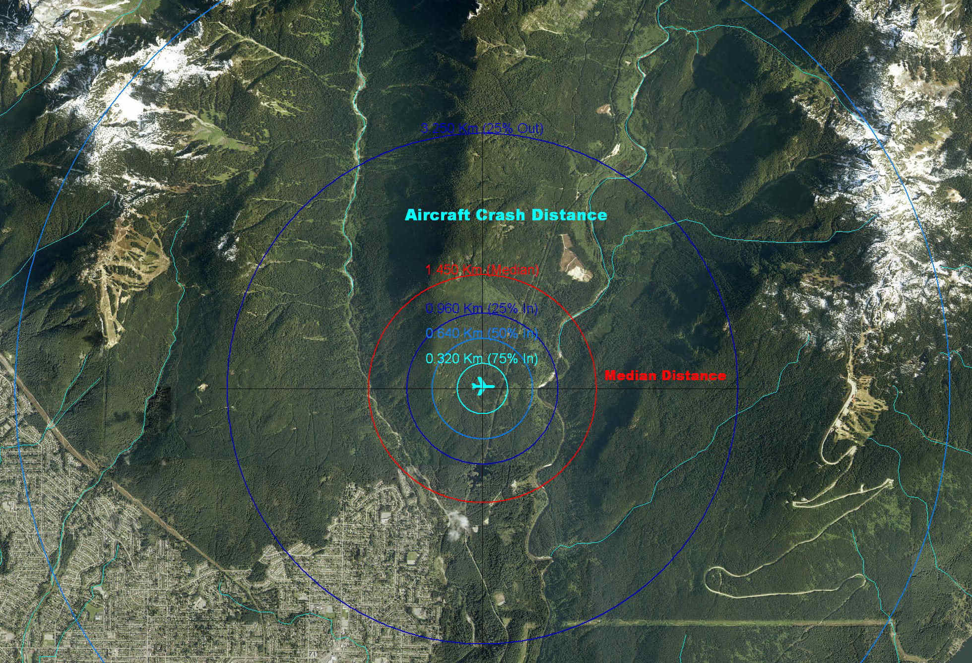
Aircraft
Crash Location Service
![]() Aircraft Debris Location
Service
Aircraft Debris Location
Service
![]() 'Incident
Commander Pro' - Air-Search Brochure
'Incident
Commander Pro' - Air-Search Brochure
![]() Aeronautical
SAR Products & Services
Aeronautical
SAR Products & Services
![]() Aircraft
Crash/Debris Location Examples
Aircraft
Crash/Debris Location Examples