![]()
![]()
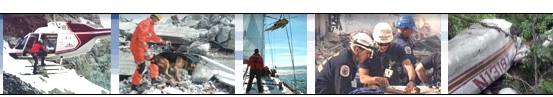
![]() SAR
Technology - Aircraft Crash Location Service
SAR
Technology - Aircraft Crash Location Service 
 |
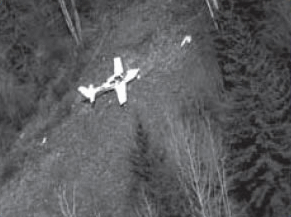
Crash Location of Missing Aircraft |
|
 |
 |
|
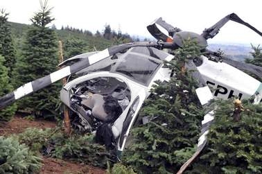
Crashed Helicopter |
 |
|
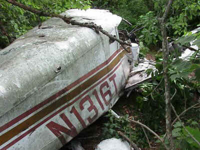
Crashed Light Aircraft |
SAR Technology is please to offer it's powerful Aircraft Crash Location Service
to help rapidly locate missing aircraft.
![]() With it's powerful new Multi-Scenario
Response system a collection of high probability crash locations can
be rapidly delivered to the responders - even as they initially respond to the mission.
With it's powerful new Multi-Scenario
Response system a collection of high probability crash locations can
be rapidly delivered to the responders - even as they initially respond to the mission.
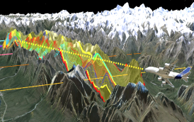
![]() The Multi-Scenario Response system rapidly predicts high probability crash
locations for each scenario under consideration - permitting responders to
quickly search each location in near real-time, for a very fast and precise
response.
The Multi-Scenario Response system rapidly predicts high probability crash
locations for each scenario under consideration - permitting responders to
quickly search each location in near real-time, for a very fast and precise
response.
 |
|
Predicted Aircraft Crash Location |
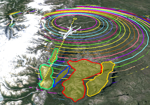
![]() With the unique
capability to predict crash locations for commercial, private and military aircraft
the Multiple Scenario Response system can be used for all types of missing aircraft.
A wide range of aircraft
parameters, weather and terrain factors are all integrated into each scenario's
predicted crash location.
With the unique
capability to predict crash locations for commercial, private and military aircraft
the Multiple Scenario Response system can be used for all types of missing aircraft.
A wide range of aircraft
parameters, weather and terrain factors are all integrated into each scenario's
predicted crash location.


![]()

 |
|
|
![]() The Aircraft Crash Location
Service is a companion to SAR Technology’s
Aircraft Debris
Location Service, which predicts the final debris-field location of an
aircraft that has disintegrated in flight, possibly due to such factors as an aircraft defect, onboard explosion or an external explosive device aimed at the aircraft.
The Aircraft Crash Location
Service is a companion to SAR Technology’s
Aircraft Debris
Location Service, which predicts the final debris-field location of an
aircraft that has disintegrated in flight, possibly due to such factors as an aircraft defect, onboard explosion or an external explosive device aimed at the aircraft.
![]() Missing Aircraft Report Complete
form... then email it to sartechnology@telus.net
Missing Aircraft Report Complete
form... then email it to sartechnology@telus.net
![]() Aircraft
Crash/Debris Location Examples
Aircraft
Crash/Debris Location Examples
![]() Aeronautical
SAR Products & Services
Aeronautical
SAR Products & Services
For more information
on the Aircraft Crash Location Service
![]()
![]() - or the Aircraft Debris Location Service
- or the Aircraft Debris Location Service
![]() Managing Air-Search
Missions - with ‘Incident
Commander Pro’
Managing Air-Search
Missions - with ‘Incident
Commander Pro’
![]() 'Incident
Commander Pro' - Air-Search Brochure
'Incident
Commander Pro' - Air-Search Brochure
![]() please contact SAR
Technology Inc.
please contact SAR
Technology Inc.
 Phone:
(604) 921-2488
Phone:
(604) 921-2488  Fax
(604) 921-2484
Fax
(604) 921-2484 ![]() sartechnology@telus.net
sartechnology@telus.net
![]() martincolwell Linked
in
martincolwell Linked
in
 |
SAR Technology Inc. |  |
View / Save / Share |