![]()
![]()
![]() 'Incident Commander
Pro - Version 8'
'Incident Commander
Pro - Version 8'

- Program Features -
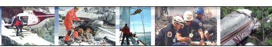
- Premier software for Search, Rescue, Safety, Security & Emergency-Response
 'Incident Commander Pro'
V8 - Powerful, field-proven tools for every
type of mission.
'Incident Commander Pro'
V8 - Powerful, field-proven tools for every
type of mission.
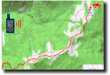
![]() Real-Time Tracking
Real-Time Tracking
for GPS-Radio, GPS-Beacon and
GPS-Smart-phones - viewed on the
advanced map display.
- Track you resources in real-time as they move through local or remote regions
- world-wide!1
 |
- One-way and two-way communication1 with your mobile resources. - receive: |
|
| |
||
|
|
||
|
|
||
|
|
|
 |
Web Map Services - Display free internet-based maps - including weather, hurricane and wildfire maps. |
| 3D Map Viewing -Draw 2D features on the map, then auto-display over Google Earth - for dramatic 3D visualization. | |
|
Track Personnel: |
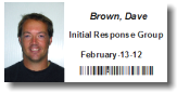 ID tags
 |
|
Track Equipment: |
 Equipment tags
 |
| Display GPS track-lines on the map. | |
|
Convert |
- for valuable insights into mission coverage. |
|
Import Personnel Data |
|
| Extensive new Planning and Mission Datasets. Many other new features and enhancements |
![]() Program
Features...
Program
Features...
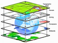
![]() GIS
Mapping
GIS
Mapping ![]() Mobile
Tracking
Mobile
Tracking
![]() Message
Alerts
Message
Alerts ![]() GPS
Plotting
GPS
Plotting ![]() Global Earth
Tools
Global Earth
Tools ![]() Message
Centre
Message
Centre
![]() GPS-Radio
Tracking
GPS-Radio
Tracking
![]() SPOT
Messenger Tracking
SPOT
Messenger Tracking ![]() SPOT
Connect Tracking
SPOT
Connect Tracking ![]() Smartphone
Tracking
Smartphone
Tracking
![]() Connected-GPS
Tracking
Connected-GPS
Tracking
![]() Skills
Skills
![]() Custom
Skills
Custom
Skills ![]() Training
Training
![]() Equipment
Equipment
![]() Barcodes
Barcodes
![]() External
Programs
External
Programs
![]() Import/Export
Import/Export
![]() Coverage/POD
Calculator
Coverage/POD
Calculator
![]() Expanded
Datasets
Expanded
Datasets ![]() Enhanced
Reporting
Enhanced
Reporting
For more information please
contact:
![]() SAR
Technology Inc.
SAR
Technology Inc.
 Phone:
(604) 921-2488
Phone:
(604) 921-2488  Fax
(604) 921-2484
Fax
(604) 921-2484  sartechnology@telus.net
 |
SAR Technology Inc. |  |
View / Save / Share |
1. Functionality
features vary depending on the selected tracking device
and and software features used.